Dinwiddie is a territorial surname and denotes ownership of land in antiquity. In early charters the territory is described as a "forty merkland of ancient extent". It comprises 10 sq. km and is bordered by the River Annan on the west, and by the Dryfe Water on the east.
It consists of rolling farmland in which two of the
modern farms bear the territorial names Dinwiddie Green and
Dinwiddie Mains. The term mains indicates that this was
the home-farm of the estate. Mains is derived from the French
demesne, hence Lord of the Manor's farm.
Dinwiddie Green, in stagecoach days, was a staging post for the London to Glasgow mail coach, which changed horses there daily.
This map shows the land bordered by the M74 on the east and lying to the north of Lockerbie. Dinwoodie mains, evidently the modern spelling of Dinwiddie mains, adjoins the M74.
The numerous hill forts and enclosures in the area indicate a considerable population in prehistoric times. There were 94 hill forts in Annandale alone.
At Dinwoodie Green a fine example of a Neolithic hand axe was excavated during the dual carriageway construction for the M74 and is now displayed in the National Museum of Antiquities in Edinburgh.
On Dinwiddie Hill there is a very large dry-stone sheepfold whose outline resembles that of a Neolithic chambered cairn of the Cairnholy I type. It is probable that the sheepfold was constructed from the remains of a robbed cairn as there are considerable lengths of dry-stone dykes around the fields. During the field enclosures of the 18th and 19th Centuries, dry-stone dykers were paid a few pence per day and had to find their own stones from the hill sides. A Neolithic chambered cairn would be a convenient source of stone. There is an historical example of this type of pillage in the New Historical Account of Scotland (1845), this states that in the nearby parish of Tundergarth, about a mile from the stone circle, on the farm of Whiteholm, there existed, until lately, two cairns of pretty large dimensions and one other on the estate of Grange. "When stones were carried away for building fences and other purposes, there were found, in the heart of them, human skeletons contained in something resembling stone coffins."
Some of the univallate (single wall), oval and circular enclosures are likely to be bronze age structures, but only excavation would verify this.
The outstanding physical feature of the territory is the hog back hill, which rises to 265 m at its northeast end. Describing this hill in 1831, the minister of the parish, in his contribution to the New Statistical Account (Vol.1V), designates it as Dinwiddie Hill, while the Ordinance Survey map labels it with the name of the nearest modern farm, Broomhill Bank.
On the summit, overlooking a steep scarp is a turf-covered, walled enclosure containing the remains of hut circles. It is oval in shape, measures 58 m by 65 m, and has two entrances. South of this enclosure lies another at an elevation of 214 m. This is an iron age, multivallate (many-walled) fort of the promontory type, the steep scarp on its east being used as the defence on that side. The diameter of the approximate circle is 70 m and the entrance is on the south side. On an enlarged aerial photograph three valla can be distinguished, but walking the site, only the inner vallum is obvious.
On the south slope below the fort is an almost square enclosure 28 metres NW to SE by 30 metres transversely, with a distinct entrance on the uphill side in the west corner. This structure is labelled on the Ordinance Survey map as Dinwoodie Graveyard. It is a levelled area surrounded by a low wall now about 0.75 m in height. The wall is constructed of large hills of boulders covered by turf. In its dimensions and construction it parallels the Celtic Sanctuary Squares which exist in Gaul and which were common to the Indo-European peoples. In the early La Tene period (500 B.C. to 250 B.C.) the cult area was a simple sacred space, delimited by a ditch and palisade. Later, simple wooden buildings were erected to house the Gods. In the Roman-British period several of these were replaced by stone temples with porticos, as a Heathrow and at Lydney. Recent discoveries of British sanctuary squares are located at Uley in Gloucestershire and at Hayling Island.
At some period after the feudal reorganisation of Annandale by David I in 1124, a Christian Chapel was built on the Dinwoodie Graveyard and the territory became a Chapelry. It is not recorded as ever having become a full parish and was eventually merged, after the Reformation, with the parishes of Sibbelbie and Apilgirth, to form the modern parish of Applegarth. The chapel was still in use in 1605 when, in a dispute with Lord Harries - a Maxwell, "Sir James Johnstone made his vow at the Kirk of Johnstone and at the Chapel of Dynwiddie" (Register of the Privy Council of Scotland). All signs of this building have now vanished.
Near the Dinwoodie Graveyard, a slight eminence is labelled on the Ordinance Survey map as Kirkstyle Knowe which indicates that an early Christian preaching cross stood there. This compares with Ruthwell Graveyard, where a site nearby is labelled Kirkstyle Knowe; almost certainly the famous 7th Century Anglican Cross thrown down at the Reformation and now treasured within the Church originally stood there.
Most probably the early cross, which stood on Dinwoodie Hill, was of wood and there is some evidence that this was one of the preaching sites of St Kentigern (Mungo- my friend) when he was domiciled at Hodelm (Hoddam) farther down the Annan Valley. St. Kentigern had been in exile in Wales following one of the frequent Anglican invasions of SW Scotland from Northumbria. After the defeat of the Angles at Arderydd (Arturet) from A.D. 573, King Ryderch Hael was restored to his Kingdom of Strathclyde and invited St. Kentigern to return to his See of Glasgow. He paused long enough in Annandale to establish a Church at Hodelm and several throughout the Valley. The parish of St. Mungo, south of Dryfesdale parish still bears his name.
David I (1124-1153) was the youngest son of King Malcolm and his English wife Queen Margaret.
He was educated in England and spent much of his youth at his uncle's court there, where his companions were young Normans. In right of his wife he became Earl of Huntingdon and Northhampton. When he succeeded his brother Alexander I to the Scottish throne he introduced Norman customs and created an aristocracy of Barons and Knights. Annandale suffered a complete change of social structure and David proceeded to give territories to his hunting companions, probably landless younger sons of the Norman aristocracy.
Annandale received Robert de Brus of the Yorkshire family as overlord and he married the heiress of Lochmaben. Ten 'Knight's fees' were created and the chieftains of the clans now held their lands by Knight-Service. Dunwidi became a Knight's fee required to supply 40 men-at-arms for the Crown. By marriage to heiresses several Anglo-Norman names now make their appearance in the Valley - e.g. del Gardine (Jardine) in Apilgith and de Locceard (Lockerbie) in Dryfesdale.
The first known record of a Dinwoodie appears in a de Brus Charter of 1191 conferring land from Dunegal, son of the Lord of Nithsdale, Udard, to William de Brus. Among signatories to this charter are Adam de Dunwidi (Dunwithie), Humphrey del Gardin and Udard de Hodelmo.
As well as land, David reorganised the church, establishing the diocesan system and dividing the country into parishes each served by a church sustained be tithes. Manorial churches were built and Dunwidi Chapel must have come into existence about this time. It is an interesting point that the Chapel was built on the ancient enclosure on Dinwidi Hill and not near the manor.
By tradition the Celtic Church was monastic. David brought in French clergy and endowed monasteries giving large tracts of land to various foreign Orders. The clergy were almost the only literates so that Crown and Barons depended on them for administration. By the time of the Reformation, so much land and its revenues was in the hands of the Church of Rome that the Crown was impoverished. A record exists that 16 acres of the lands of Dinwoodie was owned by the Order of Templars but it is not delineated.
David encouraged his knights to build castles in the Norman manner, i.e. a wooden tower and bailey on a hill or, failing that, an artificial mound to give a wide view. The next requirement was proximity to water in case of siege. The fields round were enclosed to form the demesne. The site of Dinwidi mote-and-bailey castle can be pinpointed be the position of Dinwoodie Mains. It fulfils the required criteria, standing on a low hill beside the River Annan, It is also in a strategic position over-looking the Roman Road which runs north to Moffat.
In the border feuds, which disrupted life in the 16th Century, the feuding chiefs frequently burned down each other's wooden towers. When James VI acquired the English throne in 1603, and with it the control of the English army, he determined to stamp out this lawless way of life. One of his measures was to command the border chiefs to build castellated domestic towers of stone. Many of these still stand, mostly in a ruined condition.
One very fine example, which has survived in Annandale, with additions, is Hoddam Tower. At Dinwoodie, Robert Maxwell, of Cowhill, who had acquired the Territory on the marriage of the heiress Jane Dunwedy to his brother John in 1568, met this requirement. In 1811 Dinwoodie Tower was demolished and the modern farmhouse built on the site.
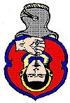
The heraldic panel, which had adorned Dinwoodie Tower, was incorporated above the main door of the new farmhouse. It is of carved stone in relief and is described in "The Royal Commission of Ancient Monuments of Scotland (1920)" thus:
Panel containing, in the centre, a shield surrounded by strap-work enrichment and having, in chief, two mullets with a human head inverted and suspended by a woodie or withie rope passed through the mouth. Above are the initials R M and beneath is the date 1631.
The 'tete coupee' links the Dinwoodie clan with the Iron Age in which the severed head was the most important cult symbol. It is significant that Robert Maxwell did not use the Maxwell Saltire as the coat of arms to adorn his new dwelling though he did indicate his younger-son status by including the two cadet-stars (mullets). The Dinwiddie family motto survived among the lesser members of the clan, decorating everyday artefacts such as fenders and clocks. It is:
Sint hostes mei
Sint is the subjective form of 'sunt' and translates roughly as So be all my enemies an echo, perhaps, of Iron Age ancestors or, perhaps, just border aggression.
| 1191 | Adam de Dunwidi | Signed a de Brus charter |
| Alano de Dunwidi | Signed a de Brus charter | |
| 1220 | Juone de Dunwidi | Married to Robert de Crossebi |
| 1220 | Sir Alan de Dunwidi | Became Seneschal of Annandale |
| 1245 | Aleyn Dunwythie | Signed the Ragman Rolls |
| 1296 | Alan de Dunwythie | Is an Esquire in the Lochmaben garrison |
| 1313 | Elisabeth of Dunwedy | Grants the lands of Wamphrey to her son, John Carruthers |
| 1447 | George de Dunwethy | Is a member of a jury at Edinburgh Tollbooth |
| 1459 | George de Dunwethy | |
| (Laird's son) | ||
| 1498 | Raided Glendowyne | |
| 1508 | Patrick Dunwedy | Hung for cross-border theft & smuggling |
| 1512 | Thomas III Dunwedy | Is a royal ward |
| 1537 | James Dinwiddy of Kirkmichael | Sued for church trends |
| 1552 | Alexander Dunwoody | Is a Laird with 41 spearmen |
| 1565 | Johnne Dunwedy | Guardian to Jane, heir and heretrix of Dunwedy, breaks the betrothal of Jane to James Johnstone of Kellobank |
| 1568 | Jane Dynwiddie | Last Dinwiddie of that family is married to John Maxwell of Aitkenhead |
| 1594 | William Dynwoodie | Was a burgess in Kirkcudbreigh |
| 1606 | Olipher Dynwiddie | A member of a jury at Drumlanrig |
| 1610 | Oliver Dynwiddie | Of Glenrae was Seneschal of the Barony of Kirkmichael |
| 1620 | Robert Dinwiddie | Of Kirkmichael, is 'put to the horn' for carrying pistols |
For centuries in Border Country, cross-border raiding and clan feuds were a way of life. In the late 16th century a particularly vicious feud, which kept Annandale and Nithsdale in turmoil, was that between the chiefs of the two dales. The Maxwells of Nithsdale were allied to the Jardines, their neighbours across the River Annan, while the Johnstones were similarly allied to their neighbours the Dynwiddies.
In spite of the fact that there was much intermarriage between the clans, there were many battles and murders. Two Lairds of Dinwoodie were murdered by the Jardines, Thomas I in 1502 at Duwedy, and Thomas II in 1512 in the streets of Edinburgh. In 1593 there was a great battle at Dryfesands in which Lord Maxwell and many of his clan were killed. Inevitably, in due course, the Laird of Johnstone suffered the same fate at the hands of Maxwell's son. "The Battle of Dryfesands" is commemorated in one of the Border Ballads romanticised by Sir Walter Scott.
During the later stages of the "Great Feud", the Lairdship of Dinwoodie changed hands several times. At one point the Laird of Johnstone claimed the territory and attempted to evict the tenants of the estate from their farms. Many lawsuits followed. In 1612 a plea was entered against eleven Dinwiddies and others, "for not flitting and removing from the lands of Dinwiddie and suffering the complainer to enter therein peaceably." The eleven listed are:
| Robert in Dinwiddie |
| John in Hangingshaw |
| Matthew in Howtoun |
| George in Broomhill |
| Johnne in Moss-syde |
| Adam in Dinwiddie Mylne |
| Gavin in Howtoun |
| William, personal retainer of Laird Robert |
| Peter in Howtoun |
| Thomas in Snab |
| John in Burne |
As the feud rumbled on, many men of the feuds were becoming Protestant and Ministers were becoming powers in the land. Complaints by the General Assembly that Lord Maxwell was attempting to revive Romanism, prompter King James to march on Dumfries in 1587 with troops. The burgesses blocked the Royal Troops long enough to allow Lord Maxwell to escape from his Castle at the top of the Venne, and he fled to Spain. Eventually, by the efforts of their kinsmen the warring chiefs were reconciled and a wary peace descended on the valleys.
Meanwhile, King James was using other means to quell troublesome subjects. He forbade some clans to use the clan surname, which introduced new surnames - Watson, Thomson. Williamson etc. One decree, which was to have far-reaching consequences, was "The Plantation of Ulster" in 1609. The Crown cleared large areas of Ulster, forcing out the legitimate owners. Troublesome Scottish families were banished from their traditional lands and settled in Ireland. There, several families of Dunwoodies are still domiciled. Famine in Ireland later caused large-scale emigration to North America, with the result that families there with the Dinwiddie surname vastly outnumber those in Scotland. There are small groups of Dinwiddies in South Africa, Australia and New Zealand. All trace their origins to Annandale.
Other websites that contain Dinwiddie family history are: